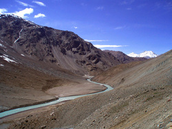
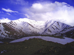
Chandra River, Batal, Himachal Pradesh, India
To reach my destination Chandra Taal (in Himachal Pradesh, India) had to depart Shoja at 04:00 hrs. The guys at the resort (Banjara Camps) were supposed to give me a wake up call at 03:00 hrs. Around 02:00 hrs, saw the time and snuggled back to sleep. When there was a knock at the door it was 03.45 hrs! Broke my previous records; got ready and raced up 136 steps (my gym instructor would have been quite proud)!The drive via Aut, Kullu and Manali was event free except that my driver tried to claim my breakfast box too (along with his own), took a wrong turn and blamed me for not carrying along the road map (which in the rush had left behind). Retaliated by giving a little demo of my dragon act and then curled up at the back seat to take a power nap!
At Solang Nala (120kms from Shoja, at an altitude of 2, 479 m/8, 135 ft.), was to switch cars (Innova to a Mahindra pickup truck), also a new driver (doubling up as a guide), a cook and porter were to join. Would be traveling about 245 kms, which was no doubt tiring but was too excited to mind.
The person who made all the arrangements (from Solang Nala onwards) assured me that this was one of the most botched up itinerary he had come across in many years! Hearing this, the permanent expression on my – a frown, just deepened.
My ordeal started as soon as stepping inside the vehicle, the body odor of the trio made me almost pass out! Alternatively gritted my teeth and bit my lips and chanted to myself ‘all for the sake of Chandra Taal’!
‘Chandra Taal’ or ‘The Moon Lake’ is in the district of Lahaul & Spiti, situated at an altitude of about 4,300m/14,000ft. The name of the lake originates from its crescent shape.
During the day, the lake appears Prussian blue in color, and a greenish tinge appears towards the evening. The lake is located on a plateau, Samudra Tapu overlooking the Chandra River, which originates from a glacier near Bara-lacha-la (also known as Bara-lacha Pass, at 4, 890 m. /16,040 ft.)
Traffic at Rothang Pass was at it’s horrendous best with road repair work on, usual tourist gathering and an oil tanker breakdown. ‘Rothang’ meaning a pile or corpses in Persian is at an altitude of 3978 m / 13,051 ft. is a high mountain pass some 51 km long from Manali, that connects the Kullu Valley with the Lahul and Spiti valleys of Himachal Pradesh, India. The pass is open from May - November, having a reputation for dangerous crossing because of unpredictable snowstorms and blizzards.
By lunchtime we reached Chhatru, a small halt station at an altitude of 3, 490 m / 11, 450ft. here one can find 3-4 shanty shop cum restaurants. Some even provide very basic night stays.
Our plan was to reach the lake by 16:00 hrs and put up our tent. Was supposed to shoot during sunset and sunrise (when the lake is at it's photographic best ) the following morning before returning to Shoja.
Though repeated assurance and information from various sources had told me that there was virtually no snowfall this year, Found the roads in a condition worse than previous. On the either side, (in places) there was about 25-30 ft. high snow deposits. As they melted in the hot sun, the roads got wet, slippery and muddy. Was no longer so resentful about having to the switch the car.
About 7-8 kms ahead of the lake there was a massive crater on the road, result of some recent boulder fall. It would be impossible for the truck to proceed. They decided to put up the tents on the bank of Chandra River and trekking seemed the only option…
November 05th, 2012
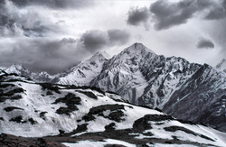
Kunzum Pass, Himachal Pradesh, India
The sun glared down, could feel sweat trickling down my spine, last 500 meters of the climb was the toughest. I almost buckled.
Reaching the top, recalled reading somewhere that ‘it is our pride, which speaks of destroying the nature, for it will destroy us much before’. Surrounded by such magnificent and dominating mountainscape it is not difficult to believe the statement.
Just as regained normal breathing and managed a couple of shots, dark clouds rolled in, the sun suddenly switched off all its warmth. Temperature dropped ominously, strong wind hurled itself and shook my barely 5 ft. / 1.52 m frame like Robert Frost’s ‘darling buds of May’! Making it impossible to hold on to my Canon EOS 5D attached to EF 100-400mm f/4.5-5.6 L IS USM lens (which poses a challenge to the wrists under normal circumstances) any longer.
It was getting difficult to breath, eyes turned watery (the CK shades providing virtually no protection except a better vision due to power lens), the eardrums were hurting and the skin broke into goose bumps (was only wearing a thick cotton top, not a very wise choice must admit).
Prior to turning back for descending, the guide pointed at C.B.13 & C.B.14 peaks (still clearly visible). Rattling off the dates of death and when their bodies were recovered.
The Valley of Lahaul also known as Chandra-Bhaga Valley, occupies the trough between the central and inner Himalayas. It is separated from Zanskar Range by snowy mountain ranges of Great Himalayan Divide and from Kullu Valley by the Central Himalayan Range. Its two major rivers known as Chandra (Origin: Chandra Taal or Moon Lake) and Bhaga (Origin: Suraj Taal or Sun Lake) crisscross the valley. In between the two rivers is a central mass of high mountains and vast glaciers. The composite massif (range) at the Dhaka Glacier between the two rivers is also called the C.B Range, abbreviation of Chandra-Bhaga. C.B 13 and C.B 14 (part of the C.B Range) are both plus 6, 000 m / 19, 685 ft. in height and are target for mountaineers from across the world. There was an air crash in this range in the sixties. Couple of years back some bodies were recovered when a mission was mounted by the personnel (instructors) of the Western Himalayan Mountaineering Institute (WHMI, Manali).
Kumzum Pass is at an altitude of 4, 551 m / 14, 931 ft. an entrance pass to Spiti Valley from Lahaul Valley in Himachal Pradesh, India.
November 6th, 2012
Black-rumped Flameback, (Dinopium benghalense), Keoladeo National Park, Bharatpur, Rajasthan, India
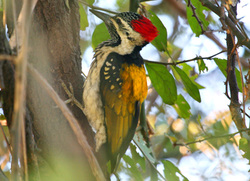
The Black-rumped Flameback (Dinopium benghalense), also known as the Lesser Golden-backed Woodpecker, is a woodpecker which is a widespread and common resident breeder in much of South Asia. It is the only Golden-backed woodpecker with a black throat.
The Black-rumped Flameback is a large species at 26-29 cm in length. The long tongue can be darted forward to capture insects. It nests in a tree hole, laying three white eggs.
This species is found in Pakistan, India south of the Himalayas and east till the western Assam valley and Meghalaya, Bangladesh and Sri Lanka. It is associated with open forest and cultivation.
Spotted this male woodpecker during one of the visits to Keoladeo National Park.
November 07th, 2012
The Other Side Of Chandra River, Chattru, Himachal Pradesh, India
Waked up to a reddish glow, the daylight infiltrating through the red tent. Would have spent that extra minute lazing inside the warm cocoon of the sleeping bags, if was not in a hurry to catch the sun winking in between the peaks.
Most taking their night stay at this halt was up, exploring around, taking photographs, sipping tea/coffee or enjoying the morning cold and crisp air. Perhaps in this moment my resolution of never taking a mountain break again of the night before fell apart quietly!
The water trickling down the mountain opposite my tent looked too inviting, but on splashing momentarily paralyzed my face; it was cold enough to match a barracuda’s bite!
With the thought of something warm to sip, headed towards the kitchen tent. Inspite of not being much into cooked breakfast, feasted on buttered toast, omelet and hot chocolate (all tasting possibly better than the gourmet meals I’ve had)!
It took a few minutes to complete my packing before reaching out for the cameras. Others dismantled the tents and loaded the truck. It was time for me to be back to Shoja with a lunch break in Solang Nala.
Before getting inside the truck I looked around for the final time and borrowed silently Arnie’s dialogue “Hasta la vista baby, I will be back!”
Note:
Chhatru is a small halt station at an altitude of 3 490 m / 11450ft.
The Chandra River is sourced from Chandra Taal or Moon Lake situated at an altitude of about 4,300 m/ 14,000 ft.
Solang Nala is at an altitude of 2 479 m / 8135 ft.
Shoja at an altitude of 2650m / 8700ft.
November 9th, 2012
Chandra Taal, Spiti, Himachal Pradesh, India
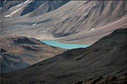
Climbing up the Kunzum Top (a moderate 1.5 km trek from Kunzum Pass at an altitude of 4551 m/14, 931 ft.) is one of the most difficult tasks I’ve ever done in my life! Panting, puffing and waddling through about 4-5 ft. snow like an aged penguin was something I had not bargained for!
My shoes and socks were wet and often I was wailing while almost sinking in the loose, fluffy snow! The cook and porter (to whom I remain eternally grateful for carrying my cam bag) had to bail me out once too often, as the guide marched ahead like Napoleon the Great leading his army! With each step they assured me that they could see the ‘lake’, while I seriously wondered if my myopic vision had deteriorated further as the only aqua I could locate was in the bottle which I held in my hand!
It didn’t take more than 15-17 minutes to get to the top (though at that time it seemed like an eternity) and there it was – the elusive!
Chandra Taal or Moon Lake is situated at an altitude of about 4,300 m/ 14,000 ft. in Spiti district of Himachal Pradesh, India. Mountains of scree overlook the lake on one side, and a magnificent cirque (an amphitheatre-like valley or valley head of glacial origin, formed by glacial erosion at the head of the glacier. Cirques are typically partially surrounded by steep cliffs) presents a view on the other. The name of the lake originates from its crescent shape. The lake is accessible only for few months in a year.
A clear stream of water flows out of the lake. During the day, the lake appears Prussian blue in color, and a greenish tinge appears towards the evening. The lake is situated on a plateau called Samudra Tapu overlooking the Chandra River which originates from a glacier near Bara-lacha-la.
November 15th, 2012
Prosperity Cup (Nepenthes hookeriana), Northern Borneo, Mulu National Park, Malaysia
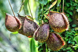
Prosperity Cup (Nepenthes hookeriana), Northern Borneo, Mulu National Park, Malaysia - 10.08.2011 The Nepenthes, popularly known as tropical pitcher plants or monkey cups, are a genus of carnivorous plants in the monotypic family Nepenthaceae. The genus comprises roughly 130 species, numerous natural and many cultivated hybrids. They are plants of the Old World tropics, ranging from South China, Indonesia, Malaysia and the Philippines; westward to Madagascar and the Seychelles; southward to Australia and New Caledonia; and northward to India and Sri Lanka. The greatest diversity occurs on Borneo and Sumatra with many endemic species. Many are plants of hot humid lowland areas, but majority are tropical montane plants, receiving warm days but cool to cold humid nights year round. A few are considered tropical alpine with cool days and nights near freezing. The name monkey cups refer to the fact that monkeys have been observed drinking rainwater from these plants.
Nepenthes species usually consist of a shallow root system and a prostrate or climbing stem, often several meters long and up to 15 m / 49 ft. or more, and usually 1 cm / 0.4 inches or less in diameter, although this may be thicker in a few species. From the stems arise alternate sword-shaped leaves with entire leaf margins. An extension of the midrib or tendril, which in some species aid in climbing, protrudes from the tip of the leaf; at the end of the tendril the pitcher forms. The pitcher starts as a small bud and gradually expands to form a globe- or tube-shaped trap.
The trap contains a fluid of the plant's own production, which may be watery or syrupy and is used to drown the prey. Research has shown that this fluid contains viscoelastic biopolymers that may be crucial to the retention of insects within the traps of many species. The trapping efficiency of this fluid remains high, even when significantly diluted by water, as inevitably happens in wet rainy conditions.
The lower part of the trap contains glands which absorb nutrients from captured prey. Along the upper inside part of the trap is a slick waxy coating which makes the escape of its prey nearly impossible. Surrounding the entrance to the trap is a structure called the peristome or the "lip" which is slippery and often quite colorful, attracting prey but offering an unsure footing. Above the peristome is a lid or operculum, in many species this keeps rain from diluting the fluid within the pitcher, the underside of which may contain nectar glands which attract prey.
Prey usually consists of insects, but the largest species may occasionally catch small vertebrates, such as rats and lizards. There are even records of cultivated plants trapping small birds. Flowers occur in racemes or more rarely in panicles with male and female flowers on separate plants. Seed is produced in a four-sided capsule which may contain 50–500 wind-distributed seeds, consisting of a central embryo and two wings, one on either side.
Most species grow in environments that provide high humidity and precipitation and moderate to high light levels. A few species prefer the dense, shaded forests, but most other species thrive on the margins of tree/shrub communities or clearings. Some species have been found growing in clear-cut forest areas, roadsides, and disturbed fields. Other species have adapted to growing in savanna-like grass communities. The soils that they grow in are usually acidic and low in nutrients, being composed of peat, white sand, sandstone, or volcanic soils. There are, however, exceptions to these generalities, including species that thrive in soils that have high heavy metal content, on sandy beaches in the sea spray zone. Other species grow on inselbergs and as lithophytes, while others can grow as epiphytes with no soil contact.
The earliest known record of Nepenthes dates back to the 17th century. In 1658, French colonial governor Etienne de Flacourt published a description of a pitcher plant in his seminal work Histoire de la Grande Isle de Madagascar.
Nepenthes hookeriana is named after Joseph Dalton Hooker, one of the greatest British botanists is a common natural hybrid involving N. rafflesiana and N. ampullaria. The said species is also known as Prosperity Cup, because it is believed that they bring good luck.
The species is present in Borneo, Peninsular Malaysia and Sumatra. The elevation in which it is found ranges from 0 - 450 m / 0 - 1, 476 ft., and commonly grows in secondary vegetation. In Borneo it has been reported from a few areas in Sabah, Sarawak and Kalimantan. Shigeo Kurata a well known Japanese botanist in 1976 reported a wider attitudinal distribution 0 - 1000 m / 0 - 3, 281 ft., but most of the habitats are situated below 100 m / 328 ft. It is found commonly in exposed habitats such as scrub vegetation, climbing among Gleichenia bushes on roadsides and regenerating waste ground and heath forest. Kurata noted it in semi-shaded and swampy forests, or sterile ground such as peat moors, and sometimes in exposed sites by streams.
November 16th, 2012
Rainbow in Oil Spill, India
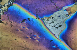
Joy knows no bound!
My highest photographic aspiration has been to get at least one single image published in National Geographic. However, it had eluded planting seeds of doubt if photography was indeed my call?
Then it changed this afternoon because my dream translated into reality! Nat Geo in their 'Environmental Literacy Teacher Guide Series - One Ocean' actually selected the adjacent photograph!
November 18th, 2012
Green Iguana, Penang Butterfly Farm, Malaysia.
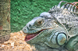
Green, or common iguana ((Iguana iguana) grow around 2 m / 6.5 ft. long and weigh about 11 lbs / 5 kgs. These reptiles are strictly herbivores and spend most of their lives in the rain forest canopy, has an average lifespan of 20 years.
November 23rd, 2012
Kunzum Top, Himachal Pradesh, India
Though the main route was blocked, there was another road to the lake but it lay deeply buried in high snow.
We would have to trek about 8 kms to reach Chandra Taal or Moon Lake. The main problem was time, it was already 16:00 hrs even if we started immediately it won’t be possible for us to proceed more than a couple of kilometers. Next morning no matter how early we started, covering 6 kms before sunrise seemed absurd. I had to be back in Shoja the same day before dark, as some parts of the road was in dire state.
Was beginning to feel the fatigue after such a long drive and sudden altitude gain, breathing was labored and my throat was feeling dry and parched. Accepted that Chandra Taal would not be possible!
The suggestion was to put up the tents just where we were and start a return journey the next morning. Did not agree to it.
For the first time in my life understood the term ‘deafening silence’. All around the landscape was extremely arid and there was not a single sign of life, it seemed that the world was dead! Could hear my own heartbeat. Unpredictability of weather was another problem nagging at the back of my mind, rain and landslide in this area is synonymous.
Told them that if reaching the lake was impossible, we should turn back and put up our tent at Chota Dhara at an altitude of 3350 m/10 991 ft. and some 22 kms away, which should make things easier for us the following morning. They agreed but was adamant that I get a glimpse of the lake!
We headed towards Kumzum Pass slightly away, at an altitude of 4551 m / 14, 931 ft. from there an uphill trek of 1.5 kms to Kunzum Top and from there could catch a glimpse of the famous Moon Lake!
November 26th, 2012
Link to WWF - India

Today did what I've been meaning to do for quite some time now, became a member of World Wildlife Fund - India chapter. Hence, some galleries in my website provides a link back to WWF. Visitors and friends please do your bit to spread online awareness. Thanks.
 RSS Feed
